

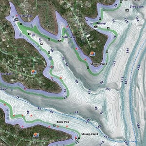
LakeV? g3 Ultra inland water maps provide industry-leading coverage, clarity and detail with integrated Garmin and Navionics data, Auto Guidance technology and high-resolution relief shading. Description LVCA100F – microSD™/SD™ card Territory Canada
- Thousands of lakes with 1? contours that feature integrated Garmin and Navionics® data
- Auto Guidance technology uses your desired depth and overhead clearance to calculate routes and a suggested path
- Many Garmin Elite survey lakes with up to 1? contours
- High-resolution relief shading combines color and shadow for an easy-to-interpret, clearer view of bottom structure
- Canada card: Covers more than 13,500 HD lakes with up to 1? contours
- U.S. East card: Over 11,500 HD lakes with up to 1? contours and more than 100 Garmin Elite survey lakes
- U.S. West card: Over 5,900 HD lakes with up to 1? contours, and more than 75 Garmin Elite survey lakes
SOME SHIPPING RESTRICTIONS AND ADDITIONAL CHARGES MAY APPLY ON THIS ITEM. IF APPLICABLE OUR TEAM WILL CONTACT FOLLOWING PURCHASE

Be the first to review “MICROSD/SD CARD LVCA100F CA”
Related products
Garmin Cartography
$100.00

Garmin Cartography
$100.00
Reviews
There are no reviews yet.